Mine surveys
Combining airborne survey technology of Lidar and Orthophoto allows the monitoring of open-cut mine progress, stockpiles, and infrastructure with an accuracy of 3.5cm. Data is delivered as DTM, DSM, and Contours but also change analysis and volumes can be supplied. Mine face analysis using hyperspectral scanners is used to identify layer structure to improve the efficiency of the mining and plant operation.
our services
We Provide The Best Services
for Mining operations
Dimap’s multi-sensor approach supports both data collection and monitoring tasks at active mines, in an effectively proven scientific and legally accepted manner. This flyer outlines how the combination of both airborne and ground-based sensors can benefit mining operations and assist mining personnel with their communications with governments and local communities.
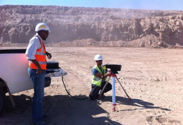
Figure 1: Mine face analysis using hyperspectral scanning to identify layers of Gypsum
Geotechnical support:
Including thermal and hyperspectral sensors in the survey allows the monitoring of:
-tiling dams (leakages),
-mine face and dump site (stability) and
-bore fields/injection bore fields.
Environmental practise:
Applying the sensor suite either airborne or from the ground allows for the establishment of environmental baselines and monitoring procedures. This can be used for:
-Dust monitoring around the mine, along roads and conveyor belts, and at the plant installations.
-Leakage analysis of chemical, gas, and water pipelines and plant installations.
-Vegetation mapping around the mine and plant for early detection of stress.
Underground mining
Utilizing a unique technology, encompassing kinematic 3D laser scanning for shaft inspections together with thermal hyperspectral enables geological and geotechnical surveys in underground mining and tunnel constructions. The technology provides high-resolution 3D models (5mm accuracy) as well as information about water seepages, ore layers, and the stability of the shaft or tunnel walls.

Figure 2: Underground water leakage under a dam mapped with airborne thermal sensors.
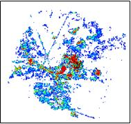
Figure 3: Dust mapping around a mining plant Banner picture: Mine train track, scanned with 5mm accuracy using Technets unique kinematic solution.