The principle of airborne Radar is the signal analysis of the reflection of radio waves in different frequencies from the surface. Radio waves can penetrate clouds and cover large areas economically for surface analysis.
Airborne RADAR is an active imaging technology that operates in the microwave portion of the electromagnetic spectrum by emitting short pulses of microwave energy and recording the reflection from a given area on the ground. The resolution of a RADAR imaging system in the cross-track direction (i.e. perpendicular to the flight path) is determined by the pulse duration (shorter pulse = higher across-track resolution), while the resolution of the RADAR in the azimuth direction (parallel to flight direction) is determined by the length of the antenna aperture (i.e. longer aperture = higher azimuth resolution).
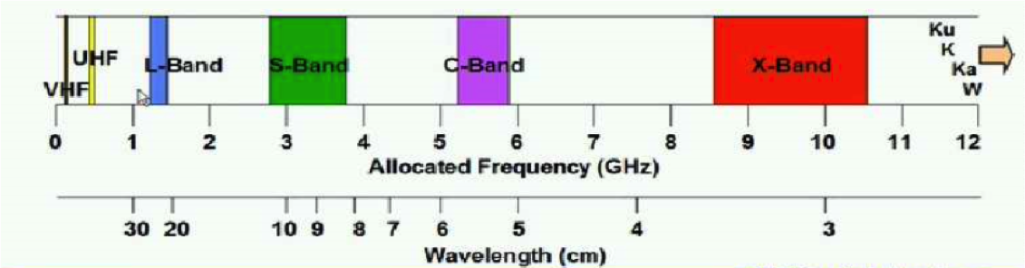
| Band | Resolution | Mode | Application |
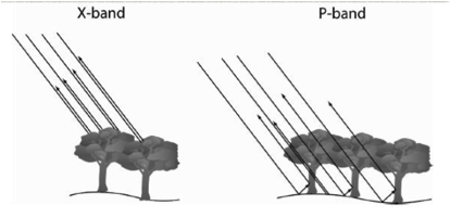
| P-Band | 75cm | Polarized | Topography in dense forest areas |
| L-Band | 75cm | Polarized | Topography in rural areas |
| X-band | 25cm | IFSAR. | Vegetation mapping Forestry |
| Ku-Band | <25cm | IFSAR | Ice and Snow surfaces |
(two bands in any given setup can be flown, frequencies are adapted to the required job)
All rights reserved with Dimap, for technical details contact: Holger.Eichstaedt@dimap-spectral.com