Skip to content
+ (852) 6977-9030
Home
About Us
Service
Applications for Mining operations
UAV
Forestry and Environmental Mapping
Engineering support
Mineral exploration and mine mapping
Urban Planning & Development
Equipment
Hyperspectral Instruments
Lidar sensor
Digital Camera
Thermal Camera
Multispectral Sensor
Operation
Auckland Project
Kilimanjaro Project
Case Studeties
Environmental Projects
Asbestos Pollution Mapping – NSW Australia
Dust Pollution Mapping – Namibia
Water Pollution – Hong Kong open seas
Forestry
Forestry Tasmania Usage of full waveform Lidar in forestry taxation
Rainforest Mapping – Malaysia
Ramin Tree Detection – Pekan Rainforests – Malaysia
Urban Forest Tree Mapping – Melbourne
Geotechnical
Glacier Survey
Pipeline Monitoring
Dimap Brochure gas
Dimap Brochure Lacq results
Dimap Brochure lublin
Mapping of Ramin Distribution
Mine Survey 2016
Further information
CoreSmart2
Radar
Aero LIDAR survey
Thermal
Hyperspectral Theory
Contact Us
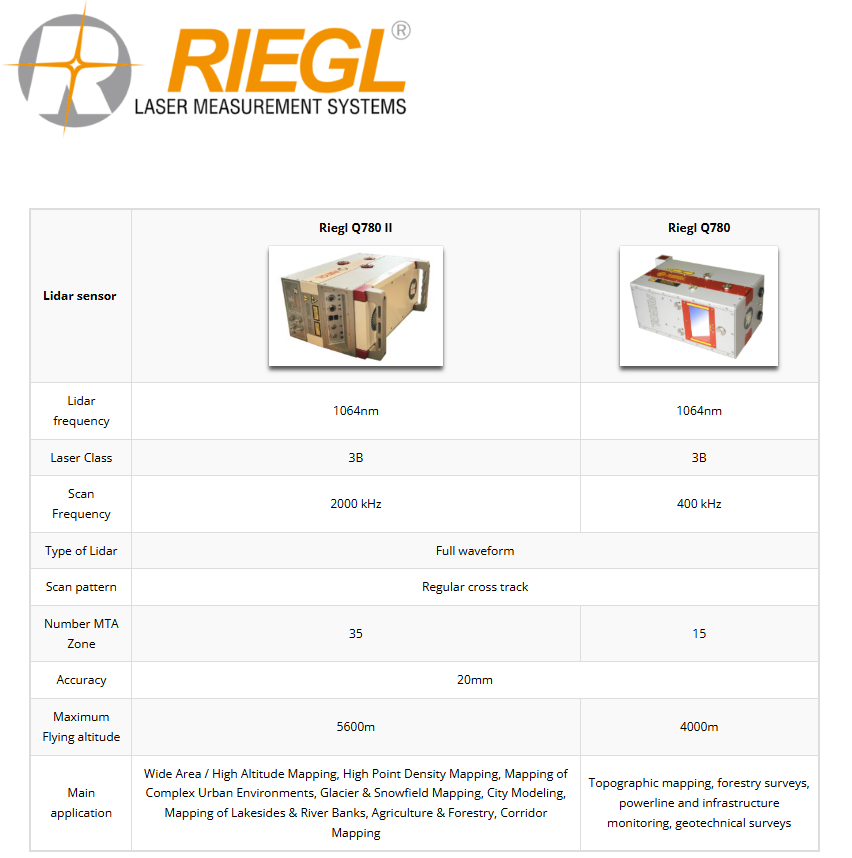
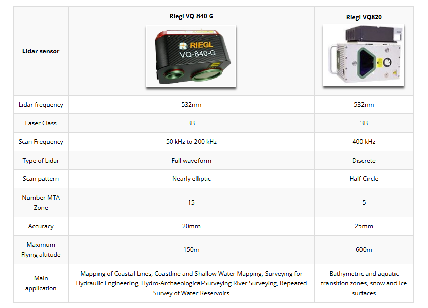
Lidar sensor
Home
Lidar sensor
RIEGL miniVUX-1UAV
Very compact & lightweight (1.55 kg / 3.4 lbs)
360° field of view
Robust aluminum housing, ready to be mounted on multi-rotor, rotary-wing, and fixed-wing UAVs
makes use of
RIEGL’s
unique echo signal digitization and online waveform processing
Multiple target capability – up to 5 target echoes per laser shot
Scan speed up to 100 scans/sec
Measurement rate 100,000 measurements/sec
Mechanical and electrical interface for IMU mounting
Exceptionally well suited to measure snowy and icy terrain
user-friendly, application- and installation-oriented solutions for integration
Main Applications
Agriculture & Forestry
Glacier and Snowfield Mapping
Archeology and Cultural Heritage Documentation
Construction-Site Monitoring
Landslide Monitoring
Back to Equipment